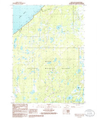
1986 Map of Kenai D-3 SE
USGS Topo · Published 1986About this map
The coastal marshlands and intricate lake systems of the Kenai National Wildlife Refuge dominate this mid-1980s survey of the Alaska peninsula. Along the northwestern edge, the waters of Cook Inlet meet a shoreline characterized by mudflats and rocky outcrops. The landscape is a dense network of water bodies, including Gruskka Lake, Scaup Lake, and Gray Cliff Lake, illustrating the complex hydrology of this subarctic environment. Small-scale industrial infrastructure appears in the form of a Pipeline and several scattered Tanks. The southern portion is defined by the winding course of the Swanson River and the proximity of a Landing Strip, suggesting the importance of small aircraft and resource management in this road-sparse region during the late twentieth century.
Find a feature on this map
15 named features on this map. Tap any name to fly to it.
Don’t see what you’re looking for? This feature index may not catch every label — zoom into the map to look around manually.
Map Details
Editions of this 1986 Kenai D-3 SE Map
This is the sole edition of this map. No revisions or reprints were ever made.
Other maps of this area

1944 · Kenai
USGS Topo · 1:250,000

1950 · Kenai
USGS Topo · 1:250,000

1950 · Kenai C-3
USGS Topo · 1:63,360

1951 · Kenai D-3
USGS Topo · 1:63,360

1951 · Kenai C-2
USGS Topo · 1:63,360

1951 · Kenai D-2
USGS Topo · 1:63,360

1951 · Kenai C-3
USGS Topo · 1:63,360

1952 · Kenai D-3
USGS Topo · 1:63,360

1952 · Kenai D-2
USGS Topo · 1:63,360

1952 · Kenai C-2
USGS Topo · 1:63,360