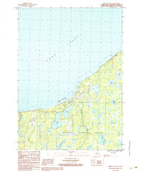
1986 Map of Kenai D-3 SW
USGS Topo · Published 1986About this map
The Cook Inlet shoreline meets a dense network of freshwater lakes and wetlands in this mid-1980s survey of the northern Kenai Peninsula. The landscape is defined by the protected wilderness of the Kenai National Wildlife Refuge and the coastal Captain Cook State Recreation Area, showing a region where conservation and resource management intersect. A prominent Pipeline cuts through the terrain, indicating the industrial infrastructure that shares this space with the natural environment.
Find a feature on this map
14 named features on this map. Tap any name to fly to it.
Don’t see what you’re looking for? This feature index may not catch every label — zoom into the map to look around manually.
Map Details
Editions of this 1986 Kenai D-3 SW Map
This is the sole edition of this map. No revisions or reprints were ever made.
Other maps of this area

1944 · Kenai
USGS Topo · 1:250,000

1950 · Kenai
USGS Topo · 1:250,000

1950 · Kenai C-3
USGS Topo · 1:63,360

1950 · Kenai D-4
USGS Topo · 1:63,360

1951 · Kenai D-3
USGS Topo · 1:63,360

1951 · Kenai C-4
USGS Topo · 1:63,360

1951 · Kenai C-3
USGS Topo · 1:63,360

1952 · Kenai D-3
USGS Topo · 1:63,360

1952 · Kenai D-4
USGS Topo · 1:63,360

1952 · Kenai C-4
USGS Topo · 1:63,360