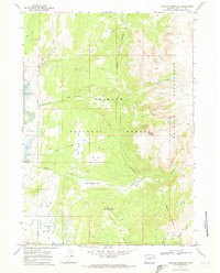
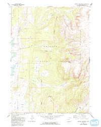
1968 Map of Kendall Mountain
USGS Topo · Published 1973About this map
Kendall Mountain dominates this portion of the Bridger National Forest, where the transition from managed forest to the high-country Bridger Wilderness is marked by a clearly defined wilderness boundary. The landscape is defined by the drainage systems of Boulder Creek and the New Fork River, which carve through deep geological features like New Fork Canyon. Local ranching and surveying history is anchored by the Circle S Ranch and the New Fork Lookout Point situated on the ridge overlooking the Boulder Basin.
Find a feature on this map
28 named features on this map. Tap any name to fly to it.
Don’t see what you’re looking for? This feature index may not catch every label — zoom into the map to look around manually.
Map Details
Editions of this 1968 Kendall Mountain Map
2 editions found
Other maps of this area

1907 · Gros Ventre
USGS Topo · 1:125,000
1909 · Fremont Peak
USGS Topo · 1:125,000

1910 · Gros Ventre
USGS Topo · 1:125,000

1955 · Driggs
USGS Topo · 1:250,000

1955 · Thermopolis
USGS Topo · 1:250,000

1958 · Driggs
USGS Topo · 1:250,000

1958 · Thermopolis
USGS Topo · 1:250,000

1962 · Thermopolis
USGS Topo · 1:250,000

1962 · Driggs
USGS Topo · 1:250,000
1966 · Warren Bridge
USGS Topo · 1:24,000