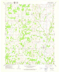
1975 Map of Kendrick
USGS Topo · Published 1979About this map
The Oil Field and petroleum infrastructure of central Oklahoma dominate this mid-1970s landscape, where dozens of wells and a Refinery are mapped between the settlements of Parkland and Kendrick. The local economy is visibly tied to extraction and transit, with the Atchison Topeka and Santa Fe railroad cutting through the eastern half of the sheet. Beyond the industrial sites, the area is defined by a dense network of watercourses, including the forks of West Beaver Creek and East Beaver Creek, which drain into the surrounding farm and ranch land. Genealogists will find significant detail in the three local burial grounds: Parkland Cem, Bethel Cem, and Kendrick Cem, which serve as anchors for the rural communities spread across Lincoln Co and the southern edge of Payne Co. A Gaging Station on Turkey Creek and several gravel pits further illustrate the active management and use of the local terrain during this era.
Find a feature on this map
23 named features on this map. Tap any name to fly to it.
Don’t see what you’re looking for? This feature index may not catch every label — zoom into the map to look around manually.
Map Details
Editions of this 1975 Kendrick Map
This is the sole edition of this map. No revisions or reprints were ever made.
Other maps of this area

1905 · Chandler
USGS Topo · 1:62,500

1907 · Chandler
USGS Topo · 1:62,500

1908 · Agra
USGS Topo · 1:62,500

1929 · Stroud
USGS Topo · 1:62,500

1931 · Drumright
USGS Topo · 1:62,500

1932 · Stroud
USGS Topo · 1:62,500

1954 · Oklahoma City
USGS Topo · 1:250,000

1957 · Oklahoma City
USGS Topo · 1:250,000

1963 · Oklahoma City
USGS Topo · 1:250,000
1974 · Chandler
USGS Topo · 1:24,000