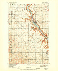
1950 Map of Kenmare
USGS Topo · Published 1950About this map
Upper Des Lacs Lake, Middle Des Lacs Lake, and Lower Des Lacs Lake form a continuous ribbon of water through this Ward County landscape, much of which is protected by the Des Lacs National Wildlife Refuge. The city of Kenmare serves as the regional hub, situated where the Soo Line and Great Northern railroads intersect at the lake's edge. Beyond the valley, the high plains are organized into a meticulous grid of townships like Elmdale, Spencer, and Crowfoot, dotted with rural schoolhouses such as Spencer Sch and Crowfoot Sch. Local history is anchored in sites like Our Savior Ch and Bethlehem Ch, while the Kenmare Landing Field and a prominent Lookout Tower reflect the mid-century infrastructure of the Missouri River Basin development era.
Find a feature on this map
49 named features on this map. Tap any name to fly to it.
Don’t see what you’re looking for? This feature index may not catch every label — zoom into the map to look around manually.
Map Details
Editions of this 1950 Kenmare Map
2 editions found

Other maps of this area

1947 · Tolley
USGS Topo · 1:62,500

1947 · Bowbells
USGS Topo · 1:24,000

1948 · Kenmare
USGS Topo · 1:24,000

1948 · Norma
USGS Topo · 1:24,000

1948 · Coteau
USGS Topo · 1:24,000

1948 · Donnybrook
USGS Topo · 1:24,000

1948 · Vanville NE
USGS Topo · 1:24,000

1949 · Mosquito Butte
USGS Topo · 1:24,000

1949 · Bowbells
USGS Topo · 1:24,000

1949 · Bowbells SE
USGS Topo · 1:24,000