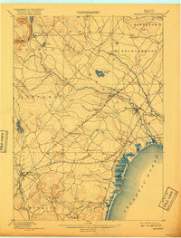
1898 Map of Kennebunk
USGS Topo · Published 1917About this map
Kennebunk and the surrounding coastal plains of York County appear here as a network of mill sites and rail depots at the close of the 19th century. The industrial character of the region is centered on the Mousam River and Kennebunk River, which supported early centers like Littlefields Mills and Kennebunk Landing. Further inland, the importance of the Boston and Maine Railroad is evident through stops such as Wells Depot and the rural junction at Wells Branch. Along the Atlantic coast, the landscape transitions from the working rivers to the growing resort communities of Kennebunk Beach, Wells Beach, and Ogunquit. This topography captures the shift from the interior timber and agricultural economy toward a maritime and early tourism-focused coastal identity, with established town centers like Alfred and North Kennebunkport anchoring the traditional York County landscape.
Find a feature on this map
44 named features on this map. Tap any name to fly to it.
Don’t see what you’re looking for? This feature index may not catch every label — zoom into the map to look around manually.
Map Details
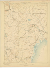
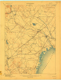
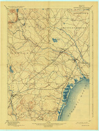
Editions of this 1898 Kennebunk Map
6 editions found


Other maps of this area

1891 · Portland
USGS Topo · 1:62,500

1891 · Biddeford
USGS Topo · 1:62,500

1891 · Berwick
USGS Topo · 1:62,500

1891 · Kennebunk
USGS Topo · 1:62,500

1891 · Buxton
USGS Topo · 1:62,500

1891 · Newfield
USGS Topo · 1:62,500

1892 · Buxton
USGS Topo · 1:62,500

1893 · Kennebunk
USGS Topo · 1:62,500

1893 · Dover
USGS Topo · 1:62,500

1893 · Berwick
USGS Topo · 1:62,500