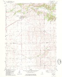
1980 Map of Kenney
USGS Topo · Published 1981About this map
The Illinois Central Gulf railroad serves as the central artery for this central Illinois landscape, cutting through the village of Kenney. This transportation corridor shaped the local economy, connecting grain elevators and rural commerce between the larger hubs of the region. The map highlights the transition between the rolling hills of the Tunbridge township and the flat, productive farmlands of Austin and Texas.
Find a feature on this map
29 named features on this map. Tap any name to fly to it.
Don’t see what you’re looking for? This feature index may not catch every label — zoom into the map to look around manually.
Map Details
Editions of this 1980 Kenney Map
This is the sole edition of this map. No revisions or reprints were ever made.
Other maps of this area

1929 · Decatur
USGS Topo · 1:62,500

1933 · Decatur
USGS Topo · 1:62,500

1954 · Niantic
USGS Topo · 1:62,500

1957 · Kenney
USGS Topo · 1:62,500

1957 · Maroa
USGS Topo · 1:62,500

1958 · Peoria
USGS Topo · 1:250,000

1958 · Decatur
USGS Topo · 1:250,000

1961 · Peoria
USGS Topo · 1:250,000

1961 · Decatur
USGS Topo · 1:250,000

1963 · Peoria
USGS Topo · 1:250,000