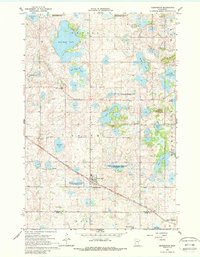
1966 Map of Kensington
USGS Topo · Published 1988About this map
Glacial topography and prairie lakes define this western Minnesota landscape, centered on the village of Kensington. The area is geographically notable for Runestone Hill, a site historically associated with local lore, and Lookout Mountain rising above the surrounding wetlands. The Soo Line railroad cuts diagonally across the terrain, serving as the primary transportation artery for the town and its grain infrastructure. Extensive conservation areas such as the Hegg Lake State Wildlife Management Area and Red Rock State Wildlife Management Area preserve the natural hydrology of the region. Family history is well-represented through the presence of rural landmarks like Solem Ch and the Wennersborg Cem, which anchor the small farming communities of Solem and Urness townships during the mid-1960s.
Find a feature on this map
37 named features on this map. Tap any name to fly to it.
Don’t see what you’re looking for? This feature index may not catch every label — zoom into the map to look around manually.
Map Details
Editions of this 1966 Kensington Map
2 editions found
Other maps of this area

1911 · Barrett
USGS Topo · 1:62,500

1912 · Morris
USGS Topo · 1:62,500

1953 · Saint Cloud
USGS Topo · 1:250,000

1957 · Saint Cloud
USGS Topo · 1:250,000

1958 · Saint Cloud
USGS Topo · 1:250,000

1966 · Brandon
USGS Topo · 1:24,000

1966 · Farwell
USGS Topo · 1:24,000

1966 · Kensington
USGS Topo · 1:24,000

1966 · Quam Lake
USGS Topo · 1:24,000

1968 · Lowry
USGS Topo · 1:24,000