
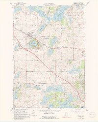
1966 Map of Brandon
USGS Topo · Published 1967About this map
Brandon serves as the focal point of this mid-1960s study, situated along the Great Northern railroad line in Douglas County. The landscape is defined by a dense concentration of glacial lakes and wetlands, including Chippewa Lake, Whisky Lake, and the expansive Lobster Lake to the south. This era shows a community deeply rooted in its rural heritage, with numerous social and religious landmarks such as the West Moe Ch and East Moe Ch, along with the Townhall and several local burial grounds like Brandon Cem and Moe Heights Cem.
Find a feature on this map
36 named features on this map. Tap any name to fly to it.
Don’t see what you’re looking for? This feature index may not catch every label — zoom into the map to look around manually.
Map Details
Editions of this 1966 Brandon Map
2 editions found
Other maps of this area

1953 · Brainerd
USGS Topo · 1:250,000

1953 · Saint Cloud
USGS Topo · 1:250,000

1957 · Brainerd
USGS Topo · 1:250,000

1957 · Saint Cloud
USGS Topo · 1:250,000

1958 · Saint Cloud
USGS Topo · 1:250,000

1958 · Brainerd
USGS Topo · 1:250,000

1965 · Brainerd
USGS Topo · 1:250,000

1966 · Alexandria West
USGS Topo · 1:24,000

1966 · Farwell
USGS Topo · 1:24,000

1966 · Kensington
USGS Topo · 1:24,000