
1966 Map of Kensington
USGS Topo · Published 1967About this map
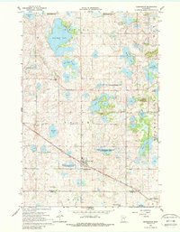
Glacial topography and a network of freshwater basins define this western Douglas County landscape in the mid-1960s. The village of Kensington serves as the primary hub, situated along the Soo Line Railroad Grade, which cuts diagonally across the prairie. The region is marked by significant historical markers, notably Runestone Hill, reflecting the local heritage and archaeological interest of the area.
Find a feature on this map
35 named features on this map. Tap any name to fly to it.
Don’t see what you’re looking for? This feature index may not catch every label — zoom into the map to look around manually.
Map Details
Editions of this 1966 Kensington Map
2 editions found
Other maps of this area

1911 · Barrett
USGS Topo · 1:62,500

1912 · Morris
USGS Topo · 1:62,500

1953 · Saint Cloud
USGS Topo · 1:250,000

1957 · Saint Cloud
USGS Topo · 1:250,000

1958 · Saint Cloud
USGS Topo · 1:250,000

1966 · Brandon
USGS Topo · 1:24,000

1966 · Farwell
USGS Topo · 1:24,000

1966 · Quam Lake
USGS Topo · 1:24,000

1968 · Lowry
USGS Topo · 1:24,000

1968 · Starbuck NW
USGS Topo · 1:24,000