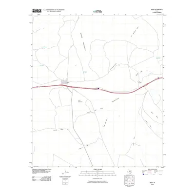
2010 Map of Kent
USGS Topo · Published 2010About this map
Kent is the primary settlement on this West Texas landscape, positioned where Interstate 10 meets regional routes like Kent Rd and Hurds Draw Rd. The terrain is defined by the southern reaches of the Apache Mountains and the prominent Kent Mountain, which rises above a series of ephemeral watercourses including Running Water Draw and Rock House Canyon. Ranching infrastructure is a visible component of the area's development, evidenced by family-named landmarks such as the Levinson Reservoir and livestock watering points like Tidwell Tank, Irby Tank, and the uniquely named In and Out Tank. The survey also documents the network of ranch access, featuring the Nelson Letsco Ranch Rd and the Twin Bridges crossing, illustrating the logistical adaptations required for transit across the desert draws and canyons.
Find a feature on this map
21 named features on this map. Tap any name to fly to it.
Don’t see what you’re looking for? This feature index may not catch every label — zoom into the map to look around manually.
Map Details
Editions of this 2010 Kent Map
This is the sole edition of this map. No revisions or reprints were ever made.
Other maps of this area

1894 · Valentine
USGS Topo · 1:125,000

1897 · Valentine
USGS Topo · 1:125,000

1928 · Kent
USGS Topo · 1:125,000

1943 · Valentine
USGS Topo · 1:125,000

1954 · Van Horn
USGS Topo · 1:250,000

1958 · Van Horn
USGS Topo · 1:250,000

1959 · Marfa
USGS Topo · 1:250,000

1965 · Marfa
USGS Topo · 1:250,000
1970 · Panther Canyon
USGS Topo · 1:24,000
1970 · San Martine
USGS Topo · 1:24,000