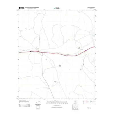
2012 Map of Kent
USGS Topo · Published 2012About this map
The high desert landscape of Kent is defined by its strategic position along transit corridors and the essential water management features of the West Texas rangeland. In this early 21st-century survey, the small community is centered near the intersection of Elda Ave and W 7th St, south of the prominent Kent Mtn. Water distribution is critical to the local economy, evidenced by numerous man-made features such as Tidwell Tank, Irby Tank, and the Levinson Reservoir. Topographic drainage patterns are mapped through several ephemeral waterways including Running Water Draw, Patterson Draw, and Cherry Cr. Transportation infrastructure is a central theme, with the Frontage Rd paralleling the primary highway and local routes like Nelson Letsco Ranch Rd and Ranch Road 2424 providing access to outlying areas like the Rancho Del Cielo Airport.
Find a feature on this map
23 named features on this map. Tap any name to fly to it.
Don’t see what you’re looking for? This feature index may not catch every label — zoom into the map to look around manually.
Map Details
Editions of this 2012 Kent Map
This is the sole edition of this map. No revisions or reprints were ever made.
Other maps of this area

1894 · Valentine
USGS Topo · 1:125,000

1897 · Valentine
USGS Topo · 1:125,000

1928 · Kent
USGS Topo · 1:125,000

1943 · Valentine
USGS Topo · 1:125,000

1954 · Van Horn
USGS Topo · 1:250,000

1958 · Van Horn
USGS Topo · 1:250,000

1959 · Marfa
USGS Topo · 1:250,000

1965 · Marfa
USGS Topo · 1:250,000
1970 · Panther Canyon
USGS Topo · 1:24,000
1970 · San Martine
USGS Topo · 1:24,000