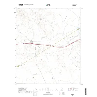
2019 Map of Kent
USGS Topo · Published 2019About this map
The small settlement of Kent serves as a lonely landmark in this high-desert region of West Texas, situated along the corridor of Interstate 10. The terrain is defined by a series of prominent peaks and drainage draws, including the southern reaches of the Apache Mountains and the distinct elevation of Kent Mtn. Water management is central to the landscape, evidenced by scattered livestock water sources such as Tidwell Tank, Irby Tank, and the Levinson Reservoir.
Find a feature on this map
25 named features on this map. Tap any name to fly to it.
Don’t see what you’re looking for? This feature index may not catch every label — zoom into the map to look around manually.
Map Details
Editions of this 2019 Kent Map
This is the sole edition of this map. No revisions or reprints were ever made.
Other maps of this area

1894 · Valentine
USGS Topo · 1:125,000

1897 · Valentine
USGS Topo · 1:125,000

1928 · Kent
USGS Topo · 1:125,000

1943 · Valentine
USGS Topo · 1:125,000

1954 · Van Horn
USGS Topo · 1:250,000

1958 · Van Horn
USGS Topo · 1:250,000

1959 · Marfa
USGS Topo · 1:250,000

1965 · Marfa
USGS Topo · 1:250,000
1970 · Panther Canyon
USGS Topo · 1:24,000
1970 · San Martine
USGS Topo · 1:24,000