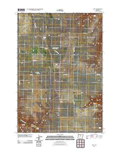
2011 Map of Kent
USGS Topo · Published 2011About this map
Kent serves as the primary settlement hub in this dry, high-plateau landscape of Sherman County, where the Kent Post Office and the Kent IOOF Cemetery anchor the community's local history. The map reveals an area defined by agricultural land use and significant water management, evidenced by the presence of Wilson Reservoir, Wilson Reservoir Number Two, and Borstel Pond. The terrain is etched by drainage systems like Finnegan Creek and Buck Hollow Creek, which feed into deep depressions such as Rock Corral Canyon and Spears Canyon. Further south, the map identifies the location of Wilcox and its associated Wilcox Cemetery, alongside the secluded Daugherty Family Cemetery near Wilcox Canyon. These family-named landmarks and remote burial grounds provide essential data for genealogists tracing the early settlers who managed the wheat fields and ranches of north-central Oregon.
Find a feature on this map
29 named features on this map. Tap any name to fly to it.
Don’t see what you’re looking for? This feature index may not catch every label — zoom into the map to look around manually.
Map Details
Editions of this 2011 Kent Map
This is the sole edition of this map. No revisions or reprints were ever made.
Other maps of this area

1953 · The Dalles
USGS Topo · 1:250,000

1956 · The Dalles
USGS Topo · 1:250,000

1957 · The Dalles
USGS Topo · 1:250,000

1962 · Grass Valley
USGS Topo · 1:24,000

1970 · Indian Cove
USGS Topo · 1:24,000

1970 · Kent
USGS Topo · 1:24,000

1970 · Macken Canyon
USGS Topo · 1:24,000

1970 · Rosebush
USGS Topo · 1:24,000
1971 · Bath Canyon
USGS Topo · 1:24,000
1971 · Horseshoe Bend
USGS Topo · 1:24,000