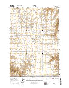
2014 Map of Kent
USGS Topo · Published 2014About this map
Kent centers this high-plateau landscape in Sherman County, where the dry landscape is deeply etched by a series of drainage systems. The small settlement is surrounded by family-named landmarks and water management features essential for life in this arid region, including Borstel Pond, Wilson Reservoir Number Two, and Wilson Reservoir. Topographic detail reveals the complex terrain south and east of the town, where Finnegan Canyon, Bronx Canyon, and Jackknife Canyon descend toward the river systems below. For those researching local lineages, the map identifies several burial sites such as the Kent IOOF Cem, Wilcox Cem, and the Daugherty Family Cem. The boundary between Sherman Co and Wasco Co is visible in the southwest, while Us-97 serves as the primary north-south artery connecting the scattered farmsteads and rangelands.
Find a feature on this map
37 named features on this map. Tap any name to fly to it.
Don’t see what you’re looking for? This feature index may not catch every label — zoom into the map to look around manually.
Map Details
Editions of this 2014 Kent Map
This is the sole edition of this map. No revisions or reprints were ever made.
Other maps of this area

1953 · The Dalles
USGS Topo · 1:250,000

1956 · The Dalles
USGS Topo · 1:250,000

1957 · The Dalles
USGS Topo · 1:250,000

1962 · Grass Valley
USGS Topo · 1:24,000

1970 · Indian Cove
USGS Topo · 1:24,000

1970 · Kent
USGS Topo · 1:24,000

1970 · Macken Canyon
USGS Topo · 1:24,000

1970 · Rosebush
USGS Topo · 1:24,000
1971 · Bath Canyon
USGS Topo · 1:24,000
1971 · Horseshoe Bend
USGS Topo · 1:24,000