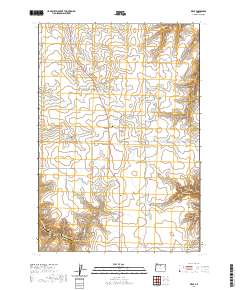
2020 Map of Kent
USGS Topo · Published 2020About this map
Kent serves as the central hub of this Sherman County landscape, situated where local routes like 2nd St and Dobie Pt Rd converge. The area is defined by a complex drainage system that has carved numerous canyons into the plateau, including Finnegan Canyon, Jackknife Canyon, and Hannafin Canyon. To the west, the Wilson Reservoir and Wilson Reservoir Number Two provide essential water management for the region, while Finnegan Creek winds through the northern sections.
Find a feature on this map
37 named features on this map. Tap any name to fly to it.
Don’t see what you’re looking for? This feature index may not catch every label — zoom into the map to look around manually.
Map Details
Editions of this 2020 Kent Map
This is the sole edition of this map. No revisions or reprints were ever made.
Other maps of this area

1953 · The Dalles
USGS Topo · 1:250,000

1956 · The Dalles
USGS Topo · 1:250,000

1957 · The Dalles
USGS Topo · 1:250,000

1962 · Grass Valley
USGS Topo · 1:24,000

1970 · Indian Cove
USGS Topo · 1:24,000

1970 · Kent
USGS Topo · 1:24,000

1970 · Macken Canyon
USGS Topo · 1:24,000

1970 · Rosebush
USGS Topo · 1:24,000
1971 · Bath Canyon
USGS Topo · 1:24,000
1971 · Horseshoe Bend
USGS Topo · 1:24,000