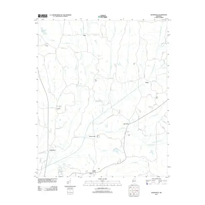
2012 Map of Keownville
USGS Topo · Published 2012About this map
Keownville and several small rural settlements are scattered across this Union County landscape, which is defined by the winding course of the Little Tallahatchie River. The river bisects the quadrangle, receiving numerous tributaries such as Pinhook Cr and Spencer Cr as it flows toward the southwest. For family historians, the map is remarkably dense with burial sites including Ebenezer Cem, Wells Chapel Cem, and Hall Cem, many of which sit adjacent to historic country road alignments. The settlement pattern remains largely agrarian, with distinct communities like Molino, Concord, and Locust Grove serving as local hubs. The topography is further marked by the presence of Rainey Lake in the northwest and the intricate drainage network formed by the N Br Wilhite Cr and its sister branches.
Find a feature on this map
101 named features on this map. Tap any name to fly to it.
Don’t see what you’re looking for? This feature index may not catch every label — zoom into the map to look around manually.
Map Details
Editions of this 2012 Keownville Map
This is the sole edition of this map. No revisions or reprints were ever made.
Other maps of this area

1949 · New Albany
USGS Topo · 1:62,500

1951 · New Albany
USGS Topo · 1:62,500

1955 · Ripley
USGS Topo · 1:62,500

1955 · Sherman
USGS Topo · 1:62,500

1955 · Blue Mountain
USGS Topo · 1:62,500

1956 · Tupelo
USGS Topo · 1:250,000

1958 · Tupelo
USGS Topo · 1:250,000

1980 · New Albany West
USGS Topo · 1:24,000
1980 · New Albany East
USGS Topo · 1:24,000
1980 · Ellistown
USGS Topo · 1:24,000