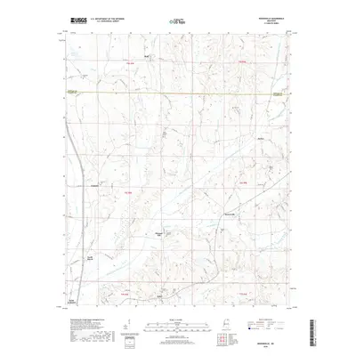
2018 Map of Keownville
USGS Topo · Published 2018About this map
The Little Tallahatchie River meanders across the center of this terrain, marking the rural heart of Union and Tippah Counties. Small settlements and crossroad communities like Keownville and Molino are scattered throughout the landscape, connected by an intricate network of county roads. For genealogists, the map is a significant record of local heritage, documenting numerous burial sites such as Mount Olivet Cem, Wells Chapel Cem, and Locust Grove Cem. The northern portion of the sheet features the Tippah and Union county line, while the southern edge touches the outskirts of New Albany. Numerous creeks, including Smith Cr, Cane Cr, and Wilhite Cr, feed into the river valley, illustrating the hydrologic structure that once dictated the placement of early homesteads and family farms in this region of northern Mississippi.
Find a feature on this map
110 named features on this map. Tap any name to fly to it.
Don’t see what you’re looking for? This feature index may not catch every label — zoom into the map to look around manually.
Map Details
Editions of this 2018 Keownville Map
This is the sole edition of this map. No revisions or reprints were ever made.
Other maps of this area

1949 · New Albany
USGS Topo · 1:62,500

1951 · New Albany
USGS Topo · 1:62,500

1955 · Ripley
USGS Topo · 1:62,500

1955 · Sherman
USGS Topo · 1:62,500

1955 · Blue Mountain
USGS Topo · 1:62,500

1956 · Tupelo
USGS Topo · 1:250,000

1958 · Tupelo
USGS Topo · 1:250,000

1980 · New Albany West
USGS Topo · 1:24,000
1980 · New Albany East
USGS Topo · 1:24,000
1980 · Ellistown
USGS Topo · 1:24,000