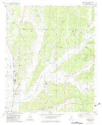
1982 Map of Keownville
USGS Topo · Published 1983About this map
The Little Tallahatchie River and its numerous tributaries, including Cane Creek and Wilhite Creek, define the landscape of this Union and Tippah County borderland. In the early 1980s, the region retained a rural character marked by a network of country churches and small family cemeteries, such as Mt Olive Ch and Roach Cem. Transportation corridors are anchored by the Gulf Mobile and Ohio and Illinois Central Gulf railroads, which parallel the north-south valleys near Concord and North Haven. The map reveals a land utilized for both agriculture and resource extraction, evidenced by scattered Gravel Pits and a Sandpit near the southern boundary. Distinctive local landmarks like Locust Grove and the settlement of Keownville provide important geographic anchors for genealogists tracing family roots in this part of Mississippi.
Find a feature on this map
53 named features on this map. Tap any name to fly to it.
Don’t see what you’re looking for? This feature index may not catch every label — zoom into the map to look around manually.
Map Details
Editions of this 1982 Keownville Map
This is the sole edition of this map. No revisions or reprints were ever made.
Other maps of this area

1949 · New Albany
USGS Topo · 1:62,500

1951 · New Albany
USGS Topo · 1:62,500

1955 · Ripley
USGS Topo · 1:62,500

1955 · Sherman
USGS Topo · 1:62,500

1955 · Blue Mountain
USGS Topo · 1:62,500

1956 · Tupelo
USGS Topo · 1:250,000

1958 · Tupelo
USGS Topo · 1:250,000

1980 · New Albany West
USGS Topo · 1:24,000
1980 · New Albany East
USGS Topo · 1:24,000
1980 · Ellistown
USGS Topo · 1:24,000