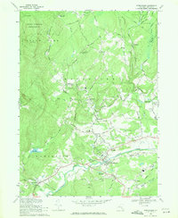
1969 Map of Kerhonkson
USGS Topo · Published 1971About this map
Rondout Creek carves a central corridor through this 1969 survey, where the infrastructure of the Delaware Aqueduct and the Old Grade Railroad intersect with long-established settlements. The landscape transitions from the protected timberlands of the State Forest Preserve in the north to the industrial and agricultural valley floors. Small hamlets like Mombaccus, Pataukunk, and Liebhardt are connected by a network of named roads such as Rochester Road and Queens Highway, reflecting a colonial-era settlement pattern that persisted into the late 20th century.
Find a feature on this map
76 named features on this map. Tap any name to fly to it.
Don’t see what you’re looking for? This feature index may not catch every label — zoom into the map to look around manually.
Map Details
Editions of this 1969 Kerhonkson Map
2 editions found
Other maps of this area

1901 · Rosendale
USGS Topo · 1:62,500

1903 · Newburg
USGS Topo · 1:62,500

1903 · Rosendale
USGS Topo · 1:62,500

1903 · Slide Mountain
USGS Topo · 1:62,500

1904 · Ellenville
USGS Topo · 1:62,500

1905 · Slide Mountain
USGS Topo · 1:62,500

1906 · Ellenville
USGS Topo · 1:62,500

1942 · West Shokan
USGS Topo · 1:24,000
1942 · Ashokan
USGS Topo · 1:24,000

1942 · Lackawack
USGS Topo · 1:24,000