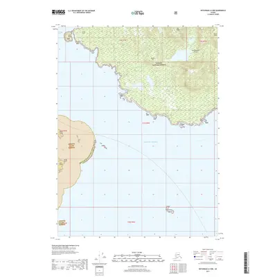
2017 Map of Ketchikan A-4 NW
USGS Topo · Published 2017About this map
Annette Island Reserve and the southern reaches of Tongass National Forest dominate this coastal landscape, where the waters of the Gulf of Alaska meet the intricate shorelines of the Alexander Archipelago. The map provides a detailed view of the maritime boundary between the Ketchikan Gateway Borough and the Prince of Wales-Hyder Census Area, cutting through the passage near Hog Rocks. Significant coastal topography is noted along the southern edge of Revillagigedo Island, including the steep elevations of Saw Ridge and Alava Ridge overlooking the entrance to Thorne Arm. This nautical-facing survey highlights numerous navigational landmarks essential to Southeast Alaska's maritime history, from the prominent Cone Point and Point Alava to smaller landmasses like Walker Island, Ham Island, and the isolated Twin Islands.
Find a feature on this map
18 named features on this map. Tap any name to fly to it.
Don’t see what you’re looking for? This feature index may not catch every label — zoom into the map to look around manually.
Map Details
Editions of this 2017 Ketchikan A-4 NW Map
This is the sole edition of this map. No revisions or reprints were ever made.
Other maps of this area

1949 · Ketchikan B-4
USGS Topo · 1:63,360

1952 · Ketchikan
USGS Topo · 1:250,000

1952 · Ketchikan B-4
USGS Topo · 1:63,360

1954 · Ketchikan B-5
USGS Topo · 1:63,360

1955 · Ketchikan A-4
USGS Topo · 1:63,360

1955 · Ketchikan A-5
USGS Topo · 1:63,360

1955 · Ketchikan
USGS Topo · 1:250,000

1955 · Ketchikan B-5
USGS Topo · 1:63,360
1994 · Ketchikan B-5
USGS Topo · 1:63,360
1995 · Ketchikan B-4
USGS Topo · 1:63,360