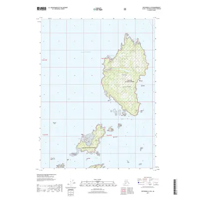
2017 Map of Ketchikan A-4 SW
USGS Topo · Published 2017About this map
Mary Island and Cat Island dominate this coastal survey of the Alexander Archipelago, illustrating the maritime character of the Tongass National Forest in Southeast Alaska. The map highlights the essential navigational features of the era, from protected waters like Customhouse Cove and Mary I Anchorage to the hazardous Bostwick Reef and Danger Passage. These islands are separated by the Felice Strait, a vital corridor for regional travel. Small landforms such as Village Island, Fripo Island, and Bird Island dot the surrounding waters, while Grave Point and Saw Ridge provide prominent landmarks for those traversing the Gulf of Alaska. The presence of labels like Point Winslow and Edge Point suggests a history of maritime surveying focused on securing safe passage through these dense island clusters and tidal channels.
Find a feature on this map
31 named features on this map. Tap any name to fly to it.
Don’t see what you’re looking for? This feature index may not catch every label — zoom into the map to look around manually.
Map Details
Editions of this 2017 Ketchikan A-4 SW Map
This is the sole edition of this map. No revisions or reprints were ever made.
Other maps of this area

1951 · Prince Rupert
USGS Topo · 1:250,000

1952 · Ketchikan
USGS Topo · 1:250,000

1955 · Ketchikan A-4
USGS Topo · 1:63,360

1955 · Ketchikan A-5
USGS Topo · 1:63,360
1955 · Prince Rupert D-5
USGS Topo · 1:63,360
1955 · Prince Rupert D-4
USGS Topo · 1:63,360

1955 · Ketchikan
USGS Topo · 1:250,000

1959 · Prince Rupert
USGS Topo · 1:250,000

1964 · Prince Rupert
USGS Topo · 1:250,000
2017 · Ketchikan A-5 SE
USGS Topo · 1:25,000