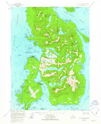
1955 Map of Ketchikan A-5
USGS Topo · Published 1963About this map
Annette Island dominates this mid-century coastal survey, centered on the community of Metlakatla and its vital maritime and aviation infrastructure. The landscape is defined by a dense network of mountains and inland water bodies, including Trout Lake and the peak of Tamgas Mtn. Evidence of mid-century industrial development is visible near the settlement, where an Aboveground Pipeline connects to Skaters Lake and a Cannery sits along the shoreline of Port Chester. The southern portion of the island is anchored by the Annette Island Airport, a critical transport link in this island geography. Beyond the main island, the map details the intricate waterways of Nichols Passage and the Revillagigedo Channel, which separate the primary landmass from Ham Island and Bold Island. The inclusion of small features like a Gravel Pit, Radio Towers, and localized Cem sites provides specific points of interest for those studying the early post-war development of the region.
Find a feature on this map
85 named features on this map. Tap any name to fly to it.
Don’t see what you’re looking for? This feature index may not catch every label — zoom into the map to look around manually.
Map Details
Editions of this 1955 Ketchikan A-5 Map
3 editions found

Other maps of this area

1948 · Prince Rupert D-6
USGS Topo · 1:63,360

1948 · Ketchikan A-6
USGS Topo · 1:63,360

1949 · Ketchikan B-4
USGS Topo · 1:63,360

1951 · Prince Rupert
USGS Topo · 1:250,000

1951 · Prince Rupert D-6
USGS Topo · 1:63,360

1952 · Ketchikan
USGS Topo · 1:250,000

1952 · Ketchikan B-4
USGS Topo · 1:63,360

1953 · Ketchikan B-6
USGS Topo · 1:63,360

1954 · Ketchikan B-5
USGS Topo · 1:63,360

1954 · Ketchikan B-6
USGS Topo · 1:63,360