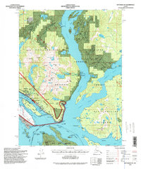
1994 Map of Ketchikan B-5
USGS Topo · Published 1998About this map
The coastal gateway of Ketchikan and the neighboring community of Saxman occupy a narrow shelf of land between the towering Deer Mts and the waters of Tongass Narrows. In this 1990s-era snapshot, the industrial and maritime infrastructure of Revillagigedo Island is on full display, from the U S Coast Guard Station to the Beaver Falls Powerhouse and several fish hatcheries. The map documents a landscape transitioning from resource extraction to conservation and tourism, noting the Mahoney Mine (Aband) and Cannery (Aband) alongside Totem Park and the Rotary Beach Picnic Area. To the south, the Annette Island Indian Reservation is visible across Nichols Passage, featuring the settlement of China Town. The intricate network of waterways like George Inlet and Clarence Strait remains the primary transit corridor, supported by the designated Marine Highway.
Find a feature on this map
99 named features on this map. Tap any name to fly to it.
Don’t see what you’re looking for? This feature index may not catch every label — zoom into the map to look around manually.
Map Details
Editions of this 1994 Ketchikan B-5 Map
This is the sole edition of this map. No revisions or reprints were ever made.
Other maps of this area

1948 · Ketchikan A-6
USGS Topo · 1:63,360

1948 · Ketchikan C-5
USGS Topo · 1:63,360

1949 · Ketchikan C-6
USGS Topo · 1:63,360

1949 · Ketchikan B-4
USGS Topo · 1:63,360

1952 · Ketchikan
USGS Topo · 1:250,000

1952 · Ketchikan B-4
USGS Topo · 1:63,360

1952 · Ketchikan C-4
USGS Topo · 1:63,360

1952 · Ketchikan C-6
USGS Topo · 1:63,360

1953 · Ketchikan C-5
USGS Topo · 1:63,360

1953 · Ketchikan B-6
USGS Topo · 1:63,360