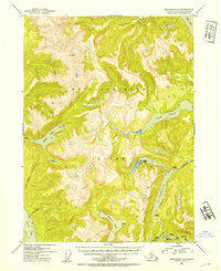
1952 Map of Ketchikan C-4
USGS Topo · Published 1954About this map
Revillagigedo Island dominates this mid-century topographic study, showcasing the complex glacial geography of the Tongass National Forest before extensive modern development. The landscape is defined by long, narrow freshwater bodies like Manzanita Lake and Lake Grace, which occupy deep troughs between peaks such as Mt Reid. Evidence of early backcountry infrastructure is visible through several strategically placed Shelter Cabins and a Gaging Sta near Lower Ella Lake, markers of the forestry and surveying work of the era. These remote outposts served as critical points for travelers and federal agents navigating the dense interior between Behm Canal and Carroll Inlet. The drainage patterns, including Calamity Creek and Looking Creek, reveal a high-relief environment where water systems are the primary corridors for exploration and mapping.
Find a feature on this map
17 named features on this map. Tap any name to fly to it.
Don’t see what you’re looking for? This feature index may not catch every label — zoom into the map to look around manually.
Map Details
Editions of this 1952 Ketchikan C-4 Map
2 editions found
Other maps of this area

1948 · Ketchikan C-5
USGS Topo · 1:63,360

1949 · Ketchikan B-4
USGS Topo · 1:63,360

1952 · Ketchikan
USGS Topo · 1:250,000

1952 · Ketchikan B-4
USGS Topo · 1:63,360

1952 · Ketchikan C-4
USGS Topo · 1:63,360

1952 · Ketchikan D-5
USGS Topo · 1:63,360

1953 · Ketchikan C-5
USGS Topo · 1:63,360

1953 · Ketchikan D-5
USGS Topo · 1:63,360

1954 · Ketchikan B-5
USGS Topo · 1:63,360

1955 · Ketchikan C-3
USGS Topo · 1:63,360