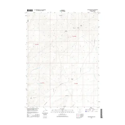
2015 Map of Ketchum Buttes
USGS Topo · Published 2015About this map
Ketchum Buttes and the surrounding high-desert topography define this Carbon County landscape as it appeared in 2015. This survey documents a complex system of drainage and relief, where prominent landmarks like Lone Butte and Cow Creek Butte anchor the horizon. The presence of McCarty Canyon Rd and Wild Cow Rd indicates the primary corridors for access through this remote range, following natural contours of the land. Water management and seasonal flow are evidenced by named features such as Lake Draw, Canary Grove Draw, and Deep Gulch. The map reveals the intricate headwaters of the regional creek system, including the three forks of Wild Cow Cr and the eastward-flowing Little Savery Cr. Researchers can also trace the historical path of Cherokee Cr in the southern sections, providing insight into the naming conventions and geographical significance of this corner of Wyoming.
Find a feature on this map
21 named features on this map. Tap any name to fly to it.
Don’t see what you’re looking for? This feature index may not catch every label — zoom into the map to look around manually.
Map Details
Editions of this 2015 Ketchum Buttes Map
This is the sole edition of this map. No revisions or reprints were ever made.
Other maps of this area

1932 · Savery
USGS Topo · 1:96,000

1940 · Savery
USGS Topo · 1:125,000

1954 · Rawlins
USGS Topo · 1:250,000

1957 · Baggs
USGS Topo · 1:62,500

1957 · Doty Mountain
USGS Topo · 1:62,500

1958 · Rawlins
USGS Topo · 1:250,000

1961 · Pine Grove Ranch
USGS Topo · 1:24,000
1961 · Browns Hill
USGS Topo · 1:24,000

1961 · Ketchum Buttes
USGS Topo · 1:24,000

1961 · Pole Gulch
USGS Topo · 1:24,000