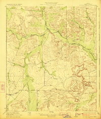
1923 Map of Ketchum Mountain
USGS Topo · Published 1923About this map
Ketchum Mountain dominates the southeastern quadrant of this West Texas landscape, rising above a network of draws and ephemeral watercourses. During the early 1920s, this portion of Irion County was defined by a ranching economy, with numerous named holdings such as 7 Bar D Ranch, Brister Ranch, and Sheen Ranch scattered across the high ground. The Middle Concho River winds through the central valley, joined by secondary drainages like Kiowa Creek and Liveoak Draw. Human activity is concentrated along the river and the primary overland routes, including the Barnhart and Mertzon Road and Stiles Road. The presence of the Burney School near Burney Ranch suggests a small but established community center for the local ranching families. Numerous wells are documented across the sheet, reflecting the critical importance of water management in this semi-arid environment.
Find a feature on this map
24 named features on this map. Tap any name to fly to it.
Don’t see what you’re looking for? This feature index may not catch every label — zoom into the map to look around manually.
Map Details
Editions of this 1923 Ketchum Mountain Map
2 editions found
Other maps of this area

1895 · Sherwood
USGS Topo · 1:125,000

1920 · Big Lake
USGS Topo · 1:62,500

1920 · Barnhart
USGS Topo · 1:62,500

1921 · Ketchum Mountain
USGS Topo · 1:62,500

1922 · Big Lake
USGS Topo · 1:62,500

1922 · Barnhart
USGS Topo · 1:62,500

1923 · Ketchum Mountain
USGS Topo · 1:62,500

1954 · San Angelo
USGS Topo · 1:250,000

1958 · San Angelo
USGS Topo · 1:250,000

1965 · San Angelo
USGS Topo · 1:250,000