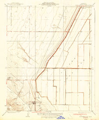
1937 Map of Kettleman City
USGS Topo · Published 1937About this map
Kettleman City and the surrounding agricultural landscape of the San Joaquin Valley appear in transition during the 1930s. The map captures an era of developing water infrastructure, dominated by the Blakeley Canal and Paso Robles Canal, which fueled the expansion of large agricultural holdings like the West Tulare Land Co and Goodfellow Ranch. The contrast between the flat Tulare Bed and the rising Kettleman Hills to the southwest is clearly defined, with Arroyo Degollado and Arroyo Robador cutting through the upland terrain. Local genealogy and land-use researchers will find significant interest in the grid of early roads, including Omaha Avenue and Quail Avenue, which connected nascent settlements such as Milham City to the regional network. The concentration of wells across the plains further illustrates the dependence on groundwater that characterized this period of California's interior development.
Find a feature on this map
18 named features on this map. Tap any name to fly to it.
Don’t see what you’re looking for? This feature index may not catch every label — zoom into the map to look around manually.
Map Details
Editions of this 1937 Kettleman City Map
3 editions found
Other maps of this area

1912 · Coalinga
USGS Topo · 1:125,000

1914 · Lost Hills
USGS Topo · 1:125,000

1914 · Cholame
USGS Topo · 1:125,000

1915 · Cholame
USGS Topo · 1:125,000

1917 · Cholame
USGS Topo · 1:125,000

1929 · Stratford
USGS Topo · 1:31,680

1929 · Westhaven
USGS Topo · 1:31,680

1930 · Discovery Well
USGS Topo · 1:31,680

1930 · Kettleman Plain
USGS Topo · 1:31,680

1930 · Middle Dome
USGS Topo · 1:31,680