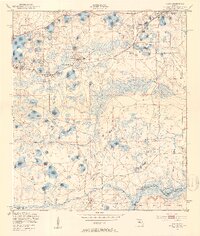
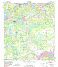
1949 Map of Keuka
USGS Topo · Published 1953About this map
The Oklawaha River forms a major geographic boundary at the southern edge of this Putnam County landscape, separating it from the northern reaches of the Ocala National Forest. In the late 1940s, this region was defined by its intricate network of lakes and creeks, including Orange Creek and Deep Creek, which supported small communities and riverfront activity at Agnews Landing and Fort Brook Landing. The Atlantic Coast Line railroad runs east-west through the northern section, connecting settlements like Interlachen and Keuka to industrial sites such as the Edgar sewage and pipe conveyor facilities.
Find a feature on this map
51 named features on this map. Tap any name to fly to it.
Don’t see what you’re looking for? This feature index may not catch every label — zoom into the map to look around manually.
Map Details
Editions of this 1949 Keuka Map
6 editions found
Other maps of this area

1893 · Citra
USGS Topo · 1:62,500

1895 · Citra
USGS Topo · 1:62,500

1915 · Interlachen
USGS Topo · 1:48,000

1916 · Interlachen
USGS Topo · 1:62,500

1938 · Hawthorn
USGS Topo · 1:48,000

1943 · Hawthorn
USGS Topo · 1:62,500

1944 · Interlachen
USGS Topo · 1:62,500

1949 · Keuka
USGS Topo · 1:24,000

1949 · Baywood
USGS Topo · 1:24,000

1949 · Rodman
USGS Topo · 1:24,000