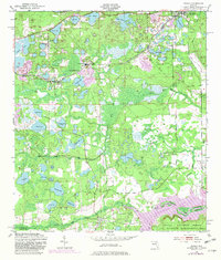
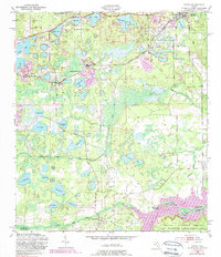
1949 Map of Keuka
USGS Topo · Published 1982About this map
Interlachen and the surrounding lake country of Putnam County define this 1949 topographic survey, capturing a landscape dominated by sandhills and a dense network of water bodies. The rail corridor of the Seaboard Coast Line connects small settlements like Keuka, Edgar, and Johnson, serving as the primary infrastructure for the area’s clay mining and citrus-era economy. Local spiritual life is evident through the placement of Mt Bethel Ch, Edgar Community Ch, and Woodlawn Ch near these rail stops.
Find a feature on this map
55 named features on this map. Tap any name to fly to it.
Don’t see what you’re looking for? This feature index may not catch every label — zoom into the map to look around manually.
Map Details
Editions of this 1949 Keuka Map
6 editions found
Other maps of this area

1893 · Citra
USGS Topo · 1:62,500

1895 · Citra
USGS Topo · 1:62,500

1915 · Interlachen
USGS Topo · 1:48,000

1916 · Interlachen
USGS Topo · 1:62,500

1938 · Hawthorn
USGS Topo · 1:48,000

1943 · Hawthorn
USGS Topo · 1:62,500

1944 · Interlachen
USGS Topo · 1:62,500

1949 · Keuka
USGS Topo · 1:24,000

1949 · Baywood
USGS Topo · 1:24,000

1949 · Rodman
USGS Topo · 1:24,000