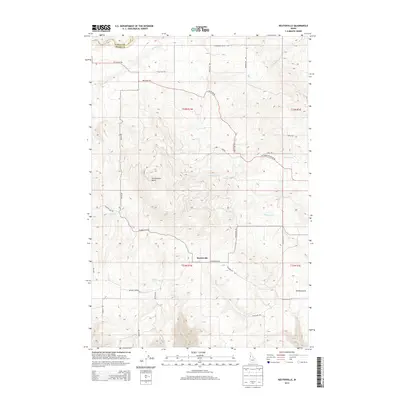
2013 Map of Keuterville
USGS Topo · Published 2013About this map
Keuterville sits at the heart of this Idaho County plateau, serving as a focal point for a landscape defined by deep drainages and high timbered ridges. The dominant physical landmark, Cottonwood Butte, rises to the northwest, overlooking a network of agricultural and mountain roads named for early families and local destinations, such as Uptmor Gehring Rd and Hussman Mill Rd. The map illustrates the complex drainage patterns of the Camas Prairie and its fringes, with numerous watercourses like Shebang Cr and Tetcher Cr cutting through the terrain. These geographical features, including the descent toward Hanley Gulch, reflect the transition from open highland farming to the steep breaks leading toward the river canyons. The survey also captures the cultural layout of the area through roads like Monastery Rd, suggesting the historical development of this rural community in the early twenty-first century.
Find a feature on this map
38 named features on this map. Tap any name to fly to it.
Don’t see what you’re looking for? This feature index may not catch every label — zoom into the map to look around manually.
Map Details
Editions of this 2013 Keuterville Map
This is the sole edition of this map. No revisions or reprints were ever made.
Other maps of this area

1924 · Kamiah
USGS Topo · 1:125,000

1955 · Pullman
USGS Topo · 1:250,000

1955 · Grangeville
USGS Topo · 1:250,000

1958 · Pullman
USGS Topo · 1:250,000

1959 · Grangeville
USGS Topo · 1:250,000

1963 · Boles
USGS Topo · 1:24,000

1963 · Moughmer Point
USGS Topo · 1:24,000
1963 · Fenn
USGS Topo · 1:24,000

1967 · Craigmont
USGS Topo · 1:24,000

1967 · Westlake
USGS Topo · 1:24,000