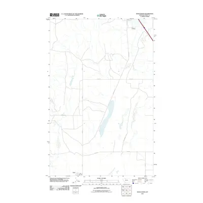
2011 Map of Kevin North
USGS Topo · Published 2011About this map
Kevin-Sunburst Oil Fld dominates the landscape of this Toole County region, a testament to the industrial history of northern Montana. The settlement of Kevin is situated at the southern edge of the sheet, served by the Kevin Fire Dept. This 2011 survey illustrates a sparse, working landscape defined by a network of straight-line section roads and industrial infrastructure. Key thoroughfares such as Sunburst Rd, Hesla Rd, and Swayze Rd connect the high plains terrain, while S Railroad Ave and 1 Mile Rd frame the outskirts of the primary settlement. The label Maggie Ward appears in the western portion of the quadrangle, marking a specific local landmark amidst the coulees and drainages that characterize this expansive prairie environment.
Find a feature on this map
10 named features on this map. Tap any name to fly to it.
Don’t see what you’re looking for? This feature index may not catch every label — zoom into the map to look around manually.
Map Details
Editions of this 2011 Kevin North Map
This is the sole edition of this map. No revisions or reprints were ever made.
Other maps of this area

1909 · Cut Bank
USGS Topo · 1:125,000

1912 · Cut Bank
USGS Topo · 1:125,000

1939 · Sunburst
USGS Topo · 1:62,500

1943 · Shelby
USGS Topo · 1:62,500

1954 · Shelby
USGS Topo · 1:250,000

1958 · Shelby
USGS Topo · 1:250,000

1960 · Cut Bank
USGS Topo · 1:250,000

1963 · Cut Bank
USGS Topo · 1:250,000

1964 · Cut Bank
USGS Topo · 1:250,000
1966 · Aloe
USGS Topo · 1:24,000