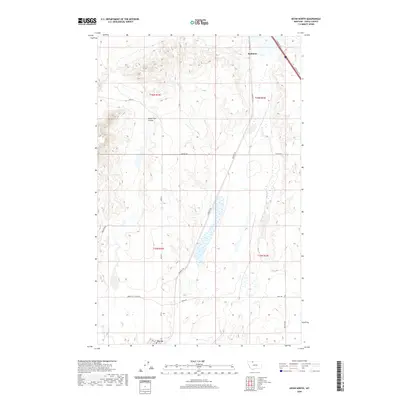
2020 Map of Kevin North
USGS Topo · Published 2020About this map
Sunburst and the northern edge of Kevin anchor this high-plains landscape in Toole County, where the topography is defined by the carved drainage of Alkali Flat Coulee. The map shows a clear transition between the organized grid of the town sites and the surrounding rural infrastructure. Transportation remains a central theme, with S Railroad Ave and the frontage roads paralleling the main corridor, while rural routes like Hesla Rd and Swayze Rd stretch across the township lines of t36n r3w and t35n r2w. This modern survey reveals how industrial and agricultural needs continue to shape the land, evidenced by features such as the Gravel Pit Access Rd. The landscape is sparse but highly structured, reflecting a classic Big Sky country settlement pattern defined by long distances and proximity to the rail line.
Find a feature on this map
16 named features on this map. Tap any name to fly to it.
Don’t see what you’re looking for? This feature index may not catch every label — zoom into the map to look around manually.
Map Details
Editions of this 2020 Kevin North Map
This is the sole edition of this map. No revisions or reprints were ever made.
Other maps of this area

1909 · Cut Bank
USGS Topo · 1:125,000

1912 · Cut Bank
USGS Topo · 1:125,000

1939 · Sunburst
USGS Topo · 1:62,500

1943 · Shelby
USGS Topo · 1:62,500

1954 · Shelby
USGS Topo · 1:250,000

1958 · Shelby
USGS Topo · 1:250,000

1960 · Cut Bank
USGS Topo · 1:250,000

1963 · Cut Bank
USGS Topo · 1:250,000

1964 · Cut Bank
USGS Topo · 1:250,000
1966 · Aloe
USGS Topo · 1:24,000