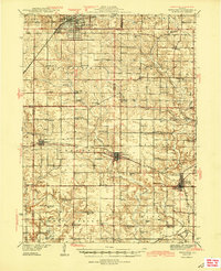
1944 Map of Kewanee
USGS Topo · Published 1944About this map
Kewanee anchors the northern edge of this Illinois landscape, which was surveyed during the early 1930s and updated in the mid-1940s. The region is defined by a dense network of rural school districts and family cemeteries, illustrating the high density of agrarian life in Henry and Stark Counties before mid-century consolidation. Small-town centers like Toulon, Wyoming, and Lafayette are connected by a trio of major rail lines, including the Chicago Burlington and Quincy and the Chicago Rock Island and Pacific.
Find a feature on this map
67 named features on this map. Tap any name to fly to it.
Don’t see what you’re looking for? This feature index may not catch every label — zoom into the map to look around manually.
Map Details
Editions of this 1944 Kewanee Map
3 editions found

Other maps of this area

1893 · Dunlap
USGS Topo · 1:62,500

1898 · Dunlap
USGS Topo · 1:62,500

1921 · Buda
USGS Topo · 1:62,500

1923 · Buda
USGS Topo · 1:62,500

1929 · Annawan
USGS Topo · 1:62,500

1931 · Galva
USGS Topo · 1:48,000

1932 · Annawan
USGS Topo · 1:62,500

1932 · Dunlap
USGS Topo · 1:62,500

1933 · Dunlap
USGS Topo · 1:62,500

1933 · Camp Grove
USGS Topo · 1:48,000