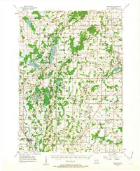
1955 Map of Kewaskum
USGS Topo · Published 1963About this map
The Kettle Moraine State Forest dominates the central axis of this landscape, showcasing the glacial topography of eastern Wisconsin through a chain of lakes including Long Lake, Mauthe Lake, and Kettle Moraine Lake. The village of Kewaskum serves as a southern anchor, while smaller farming hamlets like Batavia, Beechwood, and Dundee are scattered throughout the agricultural uplands. Notable landmarks of the mid-century era include the Parnell Lookout Tower and the Johnson Ski Jump Hill, reflecting both the conservation efforts and recreational life of the region.
Find a feature on this map
88 named features on this map. Tap any name to fly to it.
Don’t see what you’re looking for? This feature index may not catch every label — zoom into the map to look around manually.
Map Details
Editions of this 1955 Kewaskum Map
4 editions found

Other maps of this area

1892 · Port Washington
USGS Topo · 1:62,500

1904 · West Bend
USGS Topo · 1:62,500

1904 · Port Washington
USGS Topo · 1:62,500

1904 · Hartford
USGS Topo · 1:62,500

1910 · Fond du Lac
USGS Topo · 1:62,500

1954 · Sheboygan Falls
USGS Topo · 1:62,500

1954 · Howards Grove
USGS Topo · 1:62,500

1954 · Franklin
USGS Topo · 1:24,000

1954 · Kiel
USGS Topo · 1:62,500

1954 · Milwaukee
USGS Topo · 1:250,000