
1954 Map of Keweenaw Bay
USGS Topo · Published 1956About this map
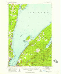
The industrial and maritime character of the Keweenaw Peninsula is evident in this mid-century survey of the waters where L'Anse Bay meets Keweenaw Bay. Centers of community life are clustered along the shoreline, from the larger hubs of Baraga and L'Anse to smaller settlements like Zeba, Assinins, and the mill-town history implied at Pequaming. The landscape shows a region in transition, where the Duluth South Shore and Atlantic railroad corridor competes with an emerging network of roads, and the legacy of earlier logging and shipping eras is visible in the network of an Old Railroad Grade and numerous small landings.
Find a feature on this map
57 named features on this map. Tap any name to fly to it.
Don’t see what you’re looking for? This feature index may not catch every label — zoom into the map to look around manually.
Map Details
Editions of this 1954 Keweenaw Bay Map
3 editions found
Other maps of this area

1915 · Houghton
USGS Topo · 1:62,500

1946 · Chassell
USGS Topo · 1:24,000

1948 · Chassell
USGS Topo · 1:24,000

1954 · Traverse Island
USGS Topo · 1:24,000

1954 · Skanee
USGS Topo · 1:62,500

1954 · Point Mills
USGS Topo · 1:24,000

1954 · Pelkie
USGS Topo · 1:62,500

1954 · Sidnaw
USGS Topo · 1:62,500

1954 · Houghton
USGS Topo · 1:62,500

1955 · Herman
USGS Topo · 1:62,500