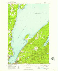
1954 Map of Keweenaw Bay
USGS Topo · Published 1958About this map
Keweenaw Bay and its rugged shoreline define this mid-century portrait of Michigan’s Upper Peninsula, where the landscape is marked by its transition from industrial heritage to forest preservation. The map details the coastal settlements of Pequaming, Assinins, and Zeba, reflecting the deep maritime and timber history of the region. Notable landmarks include the Atlantic and Western Railroad Grade, indicating the path of former logging or mineral transport lines that once crisscrossed the Peninsula. Further inland, the presence of the Aura Sch (Abandoned) and the Aura Town Hall in the settlement of Aura offers specific interest for genealogists and local historians tracking family roots in these rural communities. Along the northern edge, Portage Entry and the Portage River serve as vital connections between Torch Lake and the open waters of Lake Superior, showcasing the complex waterways that sustained the local copper-country economy.
Find a feature on this map
54 named features on this map. Tap any name to fly to it.
Don’t see what you’re looking for? This feature index may not catch every label — zoom into the map to look around manually.
Map Details
Editions of this 1954 Keweenaw Bay Map
3 editions found
Other maps of this area

1915 · Houghton
USGS Topo · 1:62,500

1946 · Chassell
USGS Topo · 1:24,000

1948 · Chassell
USGS Topo · 1:24,000

1954 · Traverse Island
USGS Topo · 1:24,000

1954 · Skanee
USGS Topo · 1:62,500

1954 · Keweenaw Bay
USGS Topo · 1:62,500

1954 · Point Mills
USGS Topo · 1:24,000

1954 · Pelkie
USGS Topo · 1:62,500

1954 · Sidnaw
USGS Topo · 1:62,500

1954 · Houghton
USGS Topo · 1:62,500