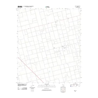
2010 Map of Key
USGS Topo · Published 2010About this map
Midway Cemetery stands as a quiet landmark in the southern reaches of this Dawson County landscape, surrounded by the industrial infrastructure of the West Spraberry Oil Field. This 2010 survey illustrates a grid of rural ranch roads, including Ranch Rd 827 and Ranch Rd 178, that define the region's agricultural and energy-driven layout. The small settlement of Key and the community of Midway serve as focal points for the local population, connected by a network of lettered and numbered county roads such as Co Rd J and Co Rd 25. The drainage of Gold Creek in the southeast corner provides a rare hydraulic feature in this largely dry, managed terrain, where the economy is clearly split between traditional ranching and petroleum extraction.
Find a feature on this map
19 named features on this map. Tap any name to fly to it.
Don’t see what you’re looking for? This feature index may not catch every label — zoom into the map to look around manually.
Map Details
Editions of this 2010 Key Map
This is the sole edition of this map. No revisions or reprints were ever made.
Other maps of this area

1954 · Big Spring
USGS Topo · 1:250,000

1958 · Big Spring
USGS Topo · 1:250,000

1968 · Lamesa North
USGS Topo · 1:24,000

1968 · Hancock
USGS Topo · 1:24,000

1969 · Indian Canyon
USGS Topo · 1:24,000

1970 · Lamesa South
USGS Topo · 1:24,000

1970 · Ackerly
USGS Topo · 1:24,000

1970 · Key
USGS Topo · 1:24,000
1970 · Tenmile
USGS Topo · 1:24,000

1970 · Sand Creek
USGS Topo · 1:24,000