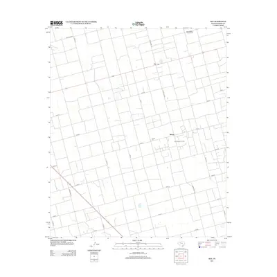
2012 Map of Key
USGS Topo · Published 2012About this map
Key and the surrounding high plains of Dawson County are characterized by a highly organized grid of rural roads and agricultural infrastructure. This region, captured during the early twenty-first century, shows a landscape defined by the extraction economy and large-scale farming. The West Spraberry Oil Field occupies a significant portion of the landscape, illustrating the intersection of energy production and rural life. Settlement centers are sparse, with Midway serving as a local focal point alongside the historic Midway Cem. Transportation is facilitated by a network of ranch roads, including Ranch Road 827 and Ranch Road 178, while the Benny White Flying Airport provides specialized aviation access for this remote area. The presence of Gold Cr offers a rare natural drainage feature in an otherwise strictly surveyed environment.
Find a feature on this map
23 named features on this map. Tap any name to fly to it.
Don’t see what you’re looking for? This feature index may not catch every label — zoom into the map to look around manually.
Map Details
Editions of this 2012 Key Map
This is the sole edition of this map. No revisions or reprints were ever made.
Other maps of this area

1954 · Big Spring
USGS Topo · 1:250,000

1958 · Big Spring
USGS Topo · 1:250,000

1968 · Lamesa North
USGS Topo · 1:24,000

1968 · Hancock
USGS Topo · 1:24,000

1969 · Indian Canyon
USGS Topo · 1:24,000

1970 · Lamesa South
USGS Topo · 1:24,000

1970 · Ackerly
USGS Topo · 1:24,000

1970 · Key
USGS Topo · 1:24,000
1970 · Tenmile
USGS Topo · 1:24,000

1970 · Sand Creek
USGS Topo · 1:24,000