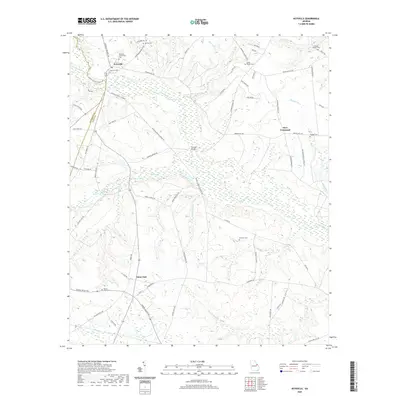
2020 Map of Keysville
USGS Topo · Published 2020About this map
Keysville serves as the primary hub in this corner of Georgia, where the boundary between Jefferson and Burke counties is defined by the winding course of Brier Creek. The landscape is a network of small watercourses and family-named landmarks, reflecting a deep-rooted rural community. Notable for genealogists are the numerous burial grounds scattered across the quadrangle, including the Keysville Community Cem, Pol Hill Cem, and Clarks Chapel Cem near the upper margins. The presence of Marks Mill-Pond and Farmers Bridge suggests a history tied to local agriculture and early milling operations along the creek banks. To the south, Saint Clair and Dyes Crossroad anchor the road network, while smaller drainages like Brushy Creek and Beaver-Dam Cr carve through the terrain, illustrating the hydrologic patterns that have shaped land use and property lines for generations.
Find a feature on this map
73 named features on this map. Tap any name to fly to it.
Don’t see what you’re looking for? This feature index may not catch every label — zoom into the map to look around manually.
Map Details
Editions of this 2020 Keysville Map
This is the sole edition of this map. No revisions or reprints were ever made.
Other maps of this area

1919 · Gough
USGS Topo · 1:62,500

1920 · Stapleton
USGS Topo · 1:62,500

1922 · Harlem
USGS Topo · 1:62,500

1922 · Hephzibah
USGS Topo · 1:62,500

1948 · Hephzibah
USGS Topo · 1:62,500

1948 · Harlem
USGS Topo · 1:62,500

1948 · Stapleton
USGS Topo · 1:62,500

1948 · Gough
USGS Topo · 1:62,500

1948 · Blythe
USGS Topo · 1:24,000
1950 · Hephzibah
USGS Topo · 1:24,000