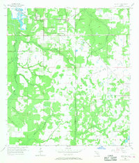
1955 Map of Keysville
USGS Topo · Published 1968About this map
Keysville and the surrounding central Florida landscape are defined by the convergence of early phosphate industry and a network of agricultural settlements during the mid-1950s. The northern portion of the region shows active industrial activity at the Strip Mine, while the Seaboard Air Line railroad provides the vital transit link through Edison and the Welcome (Station). The landscape is deeply carved by the Alafia River and its numerous tributaries, including Mizelle Creek and Halls Branch, which influenced the placement of community landmarks like Beulah Ch. Genealogists will find significant value in the documentation of family-named features and burial sites such as Blue Cem and Hunter Cem, which sit among the many creeks and pine lands before the extensive modern developments and land-use changes of the late 20th century.
Find a feature on this map
27 named features on this map. Tap any name to fly to it.
Don’t see what you’re looking for? This feature index may not catch every label — zoom into the map to look around manually.
Map Details
Editions of this 1955 Keysville Map
4 editions found
Other maps of this area

1949 · Mulberry
USGS Topo · 1:24,000

1949 · Bradley Junction
USGS Topo · 1:24,000

1950 · Mulberry
USGS Topo · 1:24,000

1950 · Bradley Junction
USGS Topo · 1:24,000

1955 · Lithia
USGS Topo · 1:24,000

1955 · Nichols
USGS Topo · 1:24,000

1955 · Dover
USGS Topo · 1:24,000

1955 · Baird
USGS Topo · 1:24,000

1955 · Keysville
USGS Topo · 1:24,000

1956 · Ft Lonesome
USGS Topo · 1:24,000