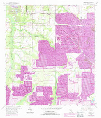
1955 Map of Keysville
USGS Topo · Published 1988About this map
The Keysville settlement and its surrounding citrus groves and phosphate operations dominate this 1955 survey of the Hillsborough and Polk County border. The landscape is defined by the intricate drainage systems of the Alafia River and South Prong Alafia River, including numerous local watercourses like Mizelle Creek, Sloman Branch, and McMullen Branch. Cultural landmarks of importance to local genealogists include Beulah Ch and rural burial sites such as Blue Cem and Hunter Cem.
Find a feature on this map
22 named features on this map. Tap any name to fly to it.
Don’t see what you’re looking for? This feature index may not catch every label — zoom into the map to look around manually.
Map Details
Editions of this 1955 Keysville Map
4 editions found
Other maps of this area

1949 · Mulberry
USGS Topo · 1:24,000

1949 · Bradley Junction
USGS Topo · 1:24,000

1950 · Mulberry
USGS Topo · 1:24,000

1950 · Bradley Junction
USGS Topo · 1:24,000

1955 · Lithia
USGS Topo · 1:24,000

1955 · Nichols
USGS Topo · 1:24,000

1955 · Dover
USGS Topo · 1:24,000

1955 · Baird
USGS Topo · 1:24,000

1955 · Keysville
USGS Topo · 1:24,000

1956 · Ft Lonesome
USGS Topo · 1:24,000