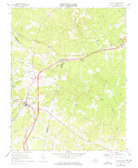
1968 Map of Keysville
USGS Topo · Published 1978About this map
The town of Keysville serves as a central hub in Southside Virginia where the Southern and Norfolk And Western railroads intersect. This 1968 field-checked landscape shows a mix of agricultural heritage and mid-century infrastructure, featuring several rural congregations such as Briery Ch and Ash Camp Ch. The surrounding countryside is defined by the headwaters of the North Meherrin River and its numerous tributaries, including Turkey Egg Creek and Little Owl Creek. Cultural landmarks of the era are clearly marked, from the Drive-in Theatre north of town to the Briery Country Club and a local Landing Strip. The map also captures the tri-county boundary lines where Charlotte Co, Prince Edward Co, and Lunenburg Co meet, providing a detailed look at the scattered settlements of Virso, Simplicity, and Bruceville.
Find a feature on this map
40 named features on this map. Tap any name to fly to it.
Don’t see what you’re looking for? This feature index may not catch every label — zoom into the map to look around manually.
Map Details
Editions of this 1968 Keysville Map
3 editions found
Other maps of this area

1891 · Farmville
USGS Topo · 1:125,000

1892 · Appomattox
USGS Topo · 1:125,000

1893 · Farmville
USGS Topo · 1:125,000

1947 · Roanoke
USGS Topo · 1:250,000

1953 · Greensboro
USGS Topo · 1:250,000

1954 · Greensboro
USGS Topo · 1:250,000

1954 · Clover
USGS Topo · 1:62,500

1955 · Chase City
USGS Topo · 1:62,500

1956 · Charlotte Court House
USGS Topo · 1:62,500

1958 · Keysville
USGS Topo · 1:62,500