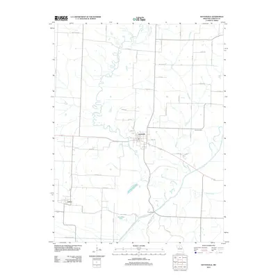
2012 Map of Keytesville
USGS Topo · Published 2012About this map
Keytesville serves as the focal point of this Chariton County landscape, where the meandering course of the Mussel Fork joins the Chariton River in a complex drainage network. The town's grid is established north of the river, connected to outlying rural areas by a dense web of county roads and named lanes like Doddley Ford Rd and Bartz Mill Ave. These road names often hint at the historical river crossings and mills that once drove the local economy.
Find a feature on this map
46 named features on this map. Tap any name to fly to it.
Don’t see what you’re looking for? This feature index may not catch every label — zoom into the map to look around manually.
Map Details
Editions of this 2012 Keytesville Map
This is the sole edition of this map. No revisions or reprints were ever made.
Other maps of this area

1890 · Glasgow
USGS Topo · 1:125,000

1890 · Marshall
USGS Topo · 1:125,000

1892 · Marshall
USGS Topo · 1:125,000

1901 · Marshall
USGS Topo · 1:125,000

1949 · Indian Grove
USGS Topo · 1:24,000

1951 · Brunswick East
USGS Topo · 1:24,000
1951 · New Frankfort
USGS Topo · 1:24,000

1953 · Moberly
USGS Topo · 1:250,000

1953 · Bynumville
USGS Topo · 1:24,000
1953 · Mike
USGS Topo · 1:24,000