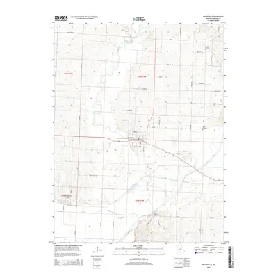
2014 Map of Keytesville
USGS Topo · Published 2014About this map
The Keytesville town center sits at a bend in the Mussel Fork, serving as the anchor for this central Missouri landscape in Chariton County. The terrain is defined by the winding paths of the Chariton River and its tributaries, including Puzzle Cr and Long Cr, which carve through the agricultural bottomlands and wooded slopes. This 2014 survey documents the enduring spatial layout of the county seat, with its grid of streets like W Jackson St and S Grand Ave clustered around the river's edge. Family history and local heritage are well-preserved across the quadrangle, which includes the Keytesville City Cemetery, Bennett Cemetery, and Varner Cemetery. The map also captures significant rural infrastructure such as the Price Bridge and a network of named roads like Bartz Mill Ave, reflecting the long-term patterns of land ownership and transit in this river valley region.
Find a feature on this map
64 named features on this map. Tap any name to fly to it.
Don’t see what you’re looking for? This feature index may not catch every label — zoom into the map to look around manually.
Map Details
Editions of this 2014 Keytesville Map
This is the sole edition of this map. No revisions or reprints were ever made.
Other maps of this area

1890 · Glasgow
USGS Topo · 1:125,000

1890 · Marshall
USGS Topo · 1:125,000

1892 · Marshall
USGS Topo · 1:125,000

1901 · Marshall
USGS Topo · 1:125,000

1949 · Indian Grove
USGS Topo · 1:24,000

1951 · Brunswick East
USGS Topo · 1:24,000
1951 · New Frankfort
USGS Topo · 1:24,000

1953 · Moberly
USGS Topo · 1:250,000

1953 · Bynumville
USGS Topo · 1:24,000
1953 · Mike
USGS Topo · 1:24,000