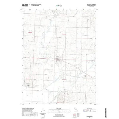
2017 Map of Keytesville
USGS Topo · Published 2017About this map
Keytesville serves as the focal point of this Chariton County landscape, where the Mussel Fork meanders south toward its confluence with the Chariton River. The terrain is defined by a network of drainage systems including Long Cr, Puzzle Cr, and Cottonwood Cr, alongside stagnant water features like Horseshoe Lake. The settlement of Dalton sits in the southwest, connected to the county seat by a grid of rural routes such as Co RD 402 and Water Well Rd.
Find a feature on this map
72 named features on this map. Tap any name to fly to it.
Don’t see what you’re looking for? This feature index may not catch every label — zoom into the map to look around manually.
Map Details
Editions of this 2017 Keytesville Map
This is the sole edition of this map. No revisions or reprints were ever made.
Other maps of this area

1890 · Glasgow
USGS Topo · 1:125,000

1890 · Marshall
USGS Topo · 1:125,000

1892 · Marshall
USGS Topo · 1:125,000

1901 · Marshall
USGS Topo · 1:125,000

1949 · Indian Grove
USGS Topo · 1:24,000

1951 · Brunswick East
USGS Topo · 1:24,000
1951 · New Frankfort
USGS Topo · 1:24,000

1953 · Moberly
USGS Topo · 1:250,000

1953 · Bynumville
USGS Topo · 1:24,000
1953 · Mike
USGS Topo · 1:24,000