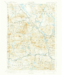
1911 Map of Kezar Falls
USGS Topo · Published 1937About this map
The Saco River meanders through this portion of western Maine and eastern New Hampshire, serving as a corridor for the Maine Central RR and early industrial settlements. In the southern half of the quadrangle, Kezar Falls emerges as a primary hub where the river crossing anchors the local community. Higher elevations are marked by the Burnt Meadow Mountains, while the lowland valleys are dotted with nineteenth-century educational and religious landmarks, including the Parsonsfield Seminary and numerous district schools like Tripptown School and Blake School.
Find a feature on this map
159 named features on this map. Tap any name to fly to it.
Don’t see what you’re looking for? This feature index may not catch every label — zoom into the map to look around manually.
Map Details
Editions of this 1911 Kezar Falls Map
5 editions found

Other maps of this area

1891 · Buxton
USGS Topo · 1:62,500

1891 · Newfield
USGS Topo · 1:62,500

1892 · Buxton
USGS Topo · 1:62,500

1893 · Buxton
USGS Topo · 1:62,500

1893 · Newfield
USGS Topo · 1:62,500

1894 · North Conway
USGS Topo · 1:62,500

1896 · Norway
USGS Topo · 1:62,500

1896 · Sebago
USGS Topo · 1:62,500

1896 · North Conway
USGS Topo · 1:62,500

1909 · Fryeburg
USGS Topo · 1:62,500