
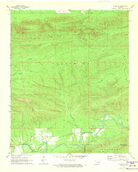
1971 Map of Kiamichi
USGS Topo · Published 1973About this map
Kiamichi River flows through the southern valley of this 1971 survey, following the tracks of the St Louis-San Francisco railroad. The landscape is defined by the prominent ridge of Buffalo Mountain to the north and the complex terrain of the Potato Hills in the center. Settlement is concentrated along the river corridor and the northern creek valleys, where family and community landmarks like the Buffalo Valley Sch, Friendship Ch, and Community Hall served the rural population.
Find a feature on this map
33 named features on this map. Tap any name to fly to it.
Don’t see what you’re looking for? This feature index may not catch every label — zoom into the map to look around manually.
Map Details
Editions of this 1971 Kiamichi Map
This is the sole edition of this map. No revisions or reprints were ever made.
Other maps of this area

1901 · Tuskahoma
USGS Topo · 1:125,000

1908 · Tuskahoma
USGS Topo · 1:125,000

1909 · Tuskahoma
USGS Topo · 1:125,000

1940 · Red Oak
USGS Topo · 1:62,500

1943 · Red Oak
USGS Topo · 1:62,500

1950 · Mcalester
USGS Topo · 1:250,000

1962 · McAlester
USGS Topo · 1:250,000

1965 · McAlester
USGS Topo · 1:250,000

1971 · Yanush
USGS Topo · 1:24,000
1971 · Albion SE
USGS Topo · 1:24,000