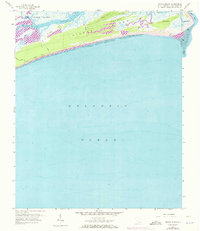
1959 Map of Kiawah Island
USGS Topo · Published 1973About this map
Kiawah Island is defined by a complex network of coastal waterways and barrier landforms along the South Carolina coast in the late 1950s. The map illustrates a landscape of expansive salt marshes and winding tidal channels, including Kiawah River and Haulover Cr, which separate the primary barrier island from Johns Island to the north. Small named settlements like Scott, Shullbred, and Van are situated along the interior reaches, connected by the simple path of Milley Road.
Find a feature on this map
22 named features on this map. Tap any name to fly to it.
Don’t see what you’re looking for? This feature index may not catch every label — zoom into the map to look around manually.
Map Details
Editions of this 1959 Kiawah Island Map
3 editions found
Other maps of this area

1918 · Kiawah Island
USGS Topo · 1:21,120

1919 · Wadmelaw Island
USGS Topo · 1:62,500

1919 · James Island
USGS Topo · 1:21,120

1919 · Legareville
USGS Topo · 1:21,120

1943 · Legareville
USGS Topo · 1:24,000

1943 · James Island
USGS Topo · 1:24,000

1943 · Kiawah Island
USGS Topo · 1:24,000

1944 · Wadmelaw Island
USGS Topo · 1:62,500

1947 · Savannah
USGS Topo · 1:250,000

1948 · James Island
USGS Topo · 1:250,000