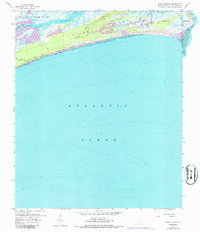
1959 Map of Kiawah Island
USGS Topo · Published 1986About this map
Kiawah Island is depicted here in a transitional state during the late 1950s, characterized by its labyrinth of saltwater marshes and tidal channels. The island is separated from Johns Island by the Kiawah River, with the landscape dominated by intricate water bodies like Haulover Cr, Cinder Creek, and Bass Creek. While much of the island remains undeveloped marshland, early infrastructure is visible through names like Vanderhorst Avenue and the oceanfront Ocean Drive. Distinctive landmarks such as Shullbred Point and Eagle Point overlook the interior waterways, while the eastern edge terminates at Sandy Point near Stono Inlet. The presence of purple revision marks indicates 1971 updates to the original 1959 survey, particularly along the road networks like Kiawah Island Rd and Milley Road, reflecting the very beginnings of modern access to this barrier island ecosystem.
Find a feature on this map
20 named features on this map. Tap any name to fly to it.
Don’t see what you’re looking for? This feature index may not catch every label — zoom into the map to look around manually.
Map Details
Editions of this 1959 Kiawah Island Map
3 editions found
Other maps of this area

1918 · Kiawah Island
USGS Topo · 1:21,120

1919 · Wadmelaw Island
USGS Topo · 1:62,500

1919 · James Island
USGS Topo · 1:21,120

1919 · Legareville
USGS Topo · 1:21,120

1943 · Legareville
USGS Topo · 1:24,000

1943 · James Island
USGS Topo · 1:24,000

1943 · Kiawah Island
USGS Topo · 1:24,000

1944 · Wadmelaw Island
USGS Topo · 1:62,500

1947 · Savannah
USGS Topo · 1:250,000

1948 · James Island
USGS Topo · 1:250,000